 | The western territories of the Chinese empire were mostly administered as protectorate during the periods of expansion; the westernmost commandery of old China was Dunhuang 敦煌郡 in the west of modern Gansu Province. The Han Dynasty 漢 installed a Protectorate of the Western Regions (Xiyu duhufu 西域都護府) with the administration center in Yanqi 焉耆. In 123 AD general Ban Yong 班勇 created the Administration Area of the Western Regions (Xiyu changshifu 西域長史府) with the center in Qiuci 龜茲. After the downfall of Han, the capital of the Western Region was shifted to Haitou 海頭 that was located west of Lake Lop Nur. In the 4th century several petty states of Chinese and Non-Chinese origin took over the control of the western regions (see Sixteen Kingdoms, the Liang states 涼). While the challengers of the Han empire was the nomad federation of the Xiongnu 匈奴, the 6th century on the Turks (Tujue 突厥) controlled the steppe zones. When the Tang Dynasty 唐 defeated the Turks they installed two protectorates, the Protectorate of the Pacified West (Anxi duhufu 安西都護府) with four garrisons (Anxi sizhen 安西四鎮: Qiuci, Yanqi, Yutian 于闐 (Khotan), and Shule 疏勒). In the 8th century regular prefectures (Yizhou 伊州, Shazhou 沙州, Tingzhou 庭州, Xizhou 西州) were installed along the northern route of the Silkroad and in 702 the Protectorate Beiting 北庭都護府. the 9th to the 10th centuries the western regions were controlled by the Tibetian empire Tubo (Tufan) 吐蕃, by the Uighurs (Huihu 回鶻), and the Karakhan empire 黑汗, the 10th century on by the Western Liao Dynasty (Xiliao 西遼). Under the Mongol Yuan Dynasty 元 the whole western region was controlled by the central government, the northwestern part by the khanates (hanguo 汗國) of Ögedei 窩闊台 and Chagatai 察合台. The Ming rulers left these territories to local potentates of Uighur or Turkic origin, the most important being the realm of "Yili town" 亦力把里 (bali is the Turkic balik "city"). Only the Manchu Qing Dynasty 清 was able to reconquer the western regions for China, and in 1759 the region was called Xinjiang 新疆 "Western Borders", administered by military prefectures. In 1885 Xinjiang became province. During the Republic the western territories were virtually autonomous and were only reincorporated into China in 1949. Today Xinjiang Autonomous Region (Xinjiang zizhiqu 新疆自治區) is inhabited by numerous Non-Chinese peoples, "ethnic minorities", the most important being Uighurs (Weiwurzu 維吾爾族), Kirgizes (Kerkezizu 柯爾克孜族), Tajiks (Tajikezu 塔吉克族), Kazaks (Hasakezu 哈薩克族), and Mongols (Mengguzu 蒙古族) . Dunhuang was the westernmost commandery (jun 郡) of the Han empire and was established to protect the trade route to Inner Asia. During Tang Dunhuang became a prefecture named Shazhou 沙州, a name that was in use until the end of Yuan. The Ming emperors established the Left Guarding Protectorate of Handong (Handong zuowei 罕東左衛) in this area, more to the south the guards Quxian 曲先衛 and Aduan 阿端衛.
Dunhuang is famous for the Buddhist Mogao Grottoes 莫高窟 than contain countless Buddhist statues and wallpaintings, but also for the excavation of numerous literary as well as historical documents written on bamboo slips. More to the west, near Anxi 安西, are the Yulin Grottoes 榆林窟 and the Eastern and Western Grottoes of the Thousand Buddhas 東西千佛洞.Name of a realm at the silkroad in the area of modern Ruoqiang 若羌, also called Qargan or Piqan. The empire of Shanshan with the capital Yuni 扜泥 (during Eastern Han called Huanni 驩泥) was famous for horses, donkeys, mules, and camels. The original name of this place is Loulan 樓蘭 a kingdom whose ruins are located near Lake Lop Nur. The Western Han (Xihan 西漢) rulers interferred into the internal politics of Shanshan and enthroned loyal kings. Emperor Han Wudi 漢武帝 installed military colonies (tuntian 屯田) for the supply of the deployed Chinese forces. During Eastern Han (Donghan 東漢) general Ban Chao 班超 had to liberate the cities along the silkroad the Xiongnu 匈奴 occupation. During the 3rd century the Shanshan disappeared. Southwards to the area of Chuoqiang 婼羌 in the Tibetian foothills (Han period). More to the east was the colonial city of Datun 大屯城 (Tang period), to the west the location of Tele 特勒 (Yuan). During the Song period this territory was controlled by the Yellow Head Uighurs (Huangtou Huihu 黃頭回鶻) and the Western Uighurs (Xizhou Huihu 西州回鶻), and the city had the name Luobu 羅卜 (origin of the name of Lake Lop Nur). Under the Ming, the area was part of the Ili Balik 亦力把里 territory.An important station along the southern route of the Silk Road, also called Qiezhi 且志 or Moguo 末國. Modern Qiemo. After the Tang period Qiemo had changing names like Boxian 播仙, Yuechang 約昌, Duchan 闍鄽 (Song), Chelichang 扯力昌 (Ming). The name "Kaqiang" 卡牆 (Cherchen, modern orthography: Qarqan) was adopted during Qing. Qiemo was famous for grapes and fruits. Southwards to Xiaoyuan 小宛 (as counterpart of Dayuan 大宛), capital Yuling 扜零城, vanished at end of Han.North of modern Minfeng 民豐, southwards to Ronglu 戎盧 and Qule 渠勒 (Han period). The old name of Minfeng is Niya 泥雅 (?). The exact location of Ronglu and the capital Bipin 卑品城 is unknown.Modern Yutian 于田. Also called Ningmi 寧彌, capital city near Kaladun 喀喇墩 (?). This area was controlled by the Western Turks during the 6th and early 7th century. The name Keliya 克里雅 or Kelediya 克勒底雅 was in use the Song period on. Westwards is the Ming period city of Qila 齊喇, modern Cele 策勒. A double city state (Western and Eastern city) located in the southern Tarim Basin at modern Hetian 和田, called Gostāna (Khotan) “Cow country”. The whole region was occupied by the Han Dynasty 漢 general Ban Chao 班超 who tried to control the trade along the silkroad. All subsequent Chinese dynasties had to cope with the benevolence of the rulers of this region and to suppress insurgencies. The most influential neighboring empire was Tibet (Tubo or Tufan 吐蕃) that during the Tang Dynasty 唐 several times was able to conquer cities along the silkroad. Yutian was the most powerful of the southern Silkroad citystates, together with Shule. Im 966 King Li Sheng 李聖 even proclaimed himself emperor. Indian and Central Asian monks had left their traces. The people of Yutian were loyal believers of Buddhism and contributed to the wall paintings and statues of the Maogao Grottoes at Dunhuang 敦煌. At the begin of the 11th century the neigboring Muslim rulers of the Karakhan empire conquered Yutian. Yutian was the first Non-Chinese country to learn the technology of silk spinning and was later famous for its silk products. The name of this city is one of the few that has constantly survived until today. In most other cases, the government of the People's Republic has revived the old Han period names. The name Khotan (modern orthography: Hotan) only seems to be a phonetic variant. The ruins of Yutian are found in Malikurvatur ("Malikewate" 瑪利克瓦特) or probably in Yurturgan ("Yuetegan" 約特干).Modern Pishan, southwards to Xiye 西夜 (Piaosha 漂沙) and Zihe 子合 (Han period), southwest to Manli 滿犁 and Yiruo 億若 (Jin), westwards to Hujian 呼鞬 (Northern Dynasties period). The capital of Zihe was Hujian Valley 呼鞬谷, some sources identify it with modern Yecheng.The city of Yecheng is a relatively new one. The place is first inhabited with the name of Zhujubo 朱俱波 or prefecture Qinan 磧南州 during the Tang period. The name of Harhalike 哈兒哈里克 (modern orthography: Kargilik) is the Qing period. Southwards to Wucha 烏秅, under Northern Wei called Yumo 於摩 or Quanmo 權摩.Also called Shache, Suoju, Shaju, Qusha 渠莎. A city state located around modern Shache. The kings of Shache could withstand the conquest of the Xiongnu 匈奴 during the disturbances after the end of Western Han (Xihan 西漢) and therfore were an important ally for the Han government to fight the Xiongnu. King Xian 賢 was denied the title of protector-general (duhu 都護) and rebelled against the Han governors of the western territory, conquering numerous city states along the silkroad. The hegemony of Shache was only ended in 61 AD, and in 87 AD general Ban Chao 班超 destroyed Shache. Later, it belonged to the realms of Yutian 于闐 and of Shule 疏勒, then again to China when general Ban Yong 班勇 carried out a second pacifying campaign in the west. Southwards to Puli 蒲犁 and Yinai 依耐 (Han period). The name Yarkan 鴨兒看 in different writing forms (雅兒看 Yarkan, 押兒牽 Yarqian, 牙兒干 Yargan, 葉爾羌 Yerqiang) is found late Tang on, modern orthography: Yarkant. Puli with the capital at the ruins of Shitou 石頭城 was the mightiest empire of the Pamir Mountains during the Han period. Duting Tang it was swallowed by Shule. Yinai was located near modern Yingjisha (Yengisar) 英吉沙, known the Tang period on as prefecture Piancheng 遍城州, in the Ming period as Yangni Balik 養泥城八里.Name of an antique kingdom or city state located in the Tarim basin, named after the River Shule ( Turkish suluk „watery“). Modern name Qašgar (Kashgar „City of heroes“; Chinese: Kashiga’r 喀什噶爾, short Kashi 喀什). Shule is the point where the northern branch and the southern branch of the silk road unite and was therefore an important trade city. While the Han 漢 empire was heavily interferring into the politics of the cities and realms along the silkroad, the subsequent dynasties installed kings of Shule and obtained their tributes without paying further attention to this region. Only during the Tang Dynasty 唐 again, the Chinese installed military commanders in this region to prevent the Turkish tribes occupying the trade routes. In the 10th century Turkish tribes founded the Islamic Karakhan (“Black Khan”; Chinese: Heihan 黑汗) empire that was incorporated into the Western Liao empire (Xiliao 西遼, Kara-Khitan) 1130 on. While the eastern part of the Karakhan empire was located around Kashgar, the western part covered the Ferghana Basin and the regions of Yutian and Qiuci. Shule is famous for its cotton production. During Tang, Shule was named prefecture Daman 達滿州, the the name of Kashgar (Keshihar 可失哈兒, Hashihar 哈實哈兒) is used the Song period on. Westwards to Juandu 捐毒 that was inhabited by Persian Sakas, capital city Yandun Valley 衍敦谷, modern Wuqia 烏恰 (Ulugqat).Ancient city state, the ruins found near Lake Lop Nur (Chinese: Luobu Bo 羅布泊), the Indo-European inhabitants being related to the states of Yanqi 焉耆 and Qiuci 龜茲. The area of Loulan was settled since neolithic times. First dominated by the Xiongnu 匈奴 nomad federation, Loulan was conquered by the troops of Han China 漢 in 108 BC although the kings of Loulan like Angui 安歸 could never get rid of the Xiongnu influence. In 77 BC the Han troops finally submitted Loulan and renamed this state in Shanshan 鄯善 and established a colonial city named Haitou 海頭 near the lake that temporarily served as capital of the Administration Area of the Western Regions (Xiyu changshifu 西域長史府). A city located beyond a desert northeast of Dunhuang, modern Hami 哈密 or Kumul (Cumul). The city was founded during Later Han as commandery Yihe 宜禾都尉城, and retained her name until the Song period as prefecture Yizhou 伊州. Northwards to Pulei 蒲類 and Pulu 蒲陸 (Han period). The name Hamili 哈密力 is known the Western Liao period on. Hami is famous for its sweet melons.The most eastern city state of the silkroad and the nearest to the most western Chinese commandery, Dunhuang 敦煌, located east modern Turfan 吐魯番 near the "Flaming Mountains" Huoyanshan xiang 火焰山鄉. The colonel city (xiaowei 校尉) Wuyi 戊已 itself was constructed by Chinese soldiers during Western Han (Xihan 西漢). Under the Former Liang Dynasty (Qianliang 前涼) Gaochang was made commandery. In 460 the Rouran 柔然 conquered the city and made it an independent state. During Tang Gaochang was made a prefecture Xizhou 西州, later it was occupied by the Western Uighurs (Xizhou Huigu 西州回鶻) who made Gaochang their capital. Gaochang was a city with a cultured mixed different sources, with believers of many religions. The city was famous for its production of wine, cotton, honey, and silk. Northwards to Cheshi 車師 (Han period) and the Bezeklik Grottoes "Bozikeli" 柏孜克里千佛洞.See Gaochang.A city state of the silkroad located at the Jiaohe River 交河 in the 亞爾乃孜Yarnaizi Valley northeast of modern Turfan 吐魯番, also called Jushi, Gushi 姑師. This city was conquered by the Han Dynasty 漢 in 89 BC by General Zhao Ponu 趙破奴 to get rid of the Xiongnu 匈奴 control over the silkroad. The Xiongnu installed a king on their own and thereby divided the country of Cheshi in two parts (Near Cheshi Qianguo 車師前國, Far Cheshi Houguo 車師後國: Beiting 北庭). Capital of Posterior Cheshi was Wutu Valley 務涂谷, the Chinese part was governed by a protector-general of the west (Xiyu duhu 西域都護), and the colony was supplied with edibles produced in militar colonies (tuntian 屯田). After the Wang Mang 王莽 disturbances it took the Han Dynasty a long time to conquer back this territory. General Dou Xian 竇憲 was able to defeat the Xiongnu in 90 AD but often rebellions of the silkroad cities occurred. Under Uighur control there was a federation of five cities (Turkic: Beš balik, Chinese: bieshi bali 別失八里) in this area. The Western Liao established prefecture Hezhou 和州 that was taken over by the Chagatai Khanate in the 13th century. West of modern Yanqi 焉耆. This place vanished in the 4th century.Name of a fort at Jinman 金滿 (modern Jimusar or Jimsar 吉木薩爾), north of the Tianshan Mountains 天山, since Later Han serving as capital of the state of Far Chechi 後車師. During Tang made prefecture Tingzhou 庭州, 702 seat of the protectorate (duhufu 都護府) and military commission (jiedushi 節都使) of Beiting. the late 9th century on Beiting was occupied by the Uighurs that made Beiting capital of the federation of the five cities (Turkic: Beš balik, Chinese: bieshi bali 別失八里) The ruins of Beiting are Pochengzi 破城子 north of Jimsar.A city state of several realms through the ages, located in modern Hui Autonomous District Yanqi. Also called Wuqi 烏耆 or Wuyi 烏夷, in Buddhist terms Agni (Chinese: Aqini 阿耆尼) like the Indian god of fire, later Solmī (Chinese: Suolimi 唆里迷), and in Islamic terms Čališ (Chinese: Chalishi 察力失). The Uighuric name is Qarašahr “Black City” (Chinese: Heicheng 黑城), the region is called Tukhāristān (Chinese: Tuhuoluo 吐火羅; the name later migrated to the southwest). The inhabitants spoke an Indo-European language called Tocharian, men shaved their head and women wore trousers. Yanqi was famous for grapes, wine, silkworms, grain and cattle, the inhabitants were good musicians.
At the begin of Western Han (Xihan 西漢) the city of Yuanqu 員渠, located at the silkroad, was controlled by the Xiongnu 匈奴 federation. When emperor Han Wudi 漢武帝 conquered this territory to control the way to Inner Asia, a protector-general of the Western Regions (Xiyu duhu 西域都護) was installed, and military colonies (tuntian 屯田) should ensure the supply of the deployed Chinese forces. the end of Western Han on the inhabitants of Yanqi stayed rebellious against the Chinese sovereignity. The stability of this region was only ensured by the Former Liang Dynasty (Qianliang 前涼) and the Northern Wei (Beiwei 北魏). the 6th century of, the city was controlled by the Turks (Tujue 突厥). Emperor Tang Taizong 唐太宗 was able to crush the power of the Turks, and again installed a protector-general and later a military commissioner (jiedushi 解度使). But after the rebellion of An Lushan 安路山 the Tang central government was weakened. Yanqi was controlled by the Huihu Uighurs under the name Solmī. At the eve of the Mongol conquest, Yanqi was an ulus (Chinese: wulusi 兀魯思), an administration territory, of the Uyghur Turks (Chinese: Weiwuer 畏兀兒). As a city located at the traditional trade routes to Inner Asia, Yanqi obtained the influence of any kind of neighboring cultures and religions. The Turkic name for Yanqi was Suolimi 唆里迷, the Mongolian name Chalishi 叉力失, the name Halashar 哈喇沙爾 (Qarashar) dates the Qing period.A place southwest of Yanqi and west to Lake Bosten (Chinese: Bositeng Hu 博斯騰湖), Uighuric name Kurle 庫爾勒 (Korla). Nearby the city of Yuli (Weili) 尉犁, during Qing called Karakum 喀喇庫木.Wulei 烏壘 (Luntai; Yengisar)   West of modern Luntai 輪台 (Bügür), place of the administration of the Protectorate of the Western Regions (Xiyu duhufu 西域都護府). The Ming period name of Luntai was Tarbugur 塔爾布古爾.A city state (Yancheng 延城) located at the silkroad, modern name Kuche 庫車, after the Turkish name Kuča (Kuca, Kutcha, Kucha; also called Qiuci 邱茲 or 丘茲, Quci 屈茨, Quzhi 屈支, Kuxian 苦先, Quxian 曲先, Kushi 庫事), the inhabitants used a language called Tocharian, affiliate to the Indo-European language family. The area around Qiuci was called Tukhāra. Since 77 BC Qiuci was obliged to pay tributes to China. Before that it had been dominated by the Xiongnu 匈奴 federation. The Qiuci had also intensive relationships with the Wusun 烏孫 tribes. Because Qiuci was one of the four Chinese garrisons of the west, it was also a place of permanent rebellions against the Chinese occupation during the Han and Tang Dynasties. The Eastern Han (Donghan 東漢) generals Ban Chao 班超 and Ban Yong 班勇 controlled this area around the year 100. In Bay 拜城, west of Kuqa, are the Buddhist Kizil Grottoes ("Kezir" 克孜爾尕哈千佛洞).Capital city Nancheng 南城, modern Aksu 阿克蘇 (Asu 阿速 or Moman 末蠻). Swallowed by Qiuci in the 6th century. Gumo was an important crossway to the north into the ara of the Wusun tribes and southwards to Yutian along the Yutian River 于闐河.Modern Wushi 烏什 (Uqturpan), during Tang period named prefecture Wensu 溫肅州, late Tang on Yukuang 于況 and the Qarluq realm (Geluolu 葛邏祿), later Woyi 倭亦 (Song) and Wuyi 烏亦(Ming). To the south is the city of Barchuk 巴爾楚克 or prefecture Weitou 尉頭州, the modern Bachu 巴楚 (Maralwexi).
This is the Chinese name for the Semi-Hellenic empire of Parthia, an empire of northern Iran, during the 3rd and 2nd centuries BC. A general term referring to a country far in the west. Some scholars interprete Daqin as Rome, the Chinese envoy of 166 AD is said to have reached the court of an emperor called "Andun 安敦" (Marcus Antoninus ?).This is the Chinese denomination for the Arabs and is derived the Arab word ţayyi' > tāzīk that is also used for the state Tajikistān. The first contact of the Chinese with the Arabs was in 751 when general Gao Xianzhi 高仙芝 wanted to defend the Soghdian citystates against the Arab general Ziyād ben Sālih.The Inner Asian realm of Bactria, located south of the Amu Darya River (modern Turkmenistan/Usbekistan), inhabited by an Indo-Iranian population that was influenced by Greek and Hellenic culture. This area was occupied by the Yuezhi 月氏 during the 2nd century CE.An Inner Asian realm located in the Ferghana Basin (Chinese: Feirganna pendi 費爾干納盆地; modern Kirgizstan) at the foots of the Pamir Mountains (Chinese: Pamir shanmai 帕米爾山脈) capital Guishan 貴山城. During the time of Emperor Han Wudi 漢武帝, an envoy named Zhang Qian 張騫 was sent out to look for the source of qualified "heavenly" horses (tianma 天馬) that were told to be bred in that area. On a second mission the Chinese envoy was killed, and Chinese troops conquered the empire of Dayuan in 104. The kingdom temporarily stood under the suzeranity of Shache. The exact location of the empire is unknown, main products were "blood sweating horses" (hanxuema 汗血馬), grapes, raisins, and hemp. During the times of the Three Kingdoms (Sanguo 三國) and the Jin Dynasty 晉 the Dayuan empire still existed, but no further official contacts were made. During Northern Wei called Poluona A fertile basin located east of the Tianshan Mountain range 天山 and surrounded by high mountain chains that today are part of Kirgizstan while the basin belongs to Uzbekistan, Chinese: Feirganna 費爾干納盆地. During the Han period the Ferghana area was famous for its "heavenly horses", and Emperor Han Wudi 漢武帝 sent Zhang Qian 張騫 as an envoy to establish relationships with the Dayuan 大宛 empire. After passing Shule (Kashgar) traders of the Silkroad had to pass the Ferghana Basin on their way to Central Asia.A kingdom located in the north of modern Afghanistan, Kashmere, and Pakistan, founded in the late 1st century BC, also named Kuşāņa. The founders of the kingdom of Kushana are said to be descendants of the Indo-Scythian Yuezhi 月氏 after they were forced by the Xiongnu 匈奴 and Wusun 烏孫 to withdraw the area of modern Xinjiang in China. Their mightiest kings were Kanişka (Chinese: Jianiseqie 迦膩色伽) under whose rule Buddhism found its was to Inner Asia and further to China, and Vasudeva (Chinese: Botiao 波調) in the 3rd century.The Hephthalites (Greek name) are called White Huns by Western scholars because they are believed to be descendants or a sideline of the Huns. In Chinese, this people is called Yada [口+厭]噠, Xieda [口+歇]噠, Yanda 囐噠, or Gu 滑. In the 470es the Hephthalites migrated into the Soghdiana, half a century later they occupied the northeastern part of Persia and Tukharistan where they endangered the Persian empire, northern India and the city states of the Tarim Basin. In the 6th century the southern expansion of the Hephthalites found its end in India, and the Persian empire forged an alliance with the Turks to defeat the Hephthalites. In 567 the empire of the White Huns was shattered. The Hephthalites believed in Nestorianism and Manicheism, their language is unknown.The Soghdiana (Chinese: Sute 粟特 or Suli 窣利) is a fertile river plain between the Amu-Darya and Syr-Darya in modern Uzbekistan (Western Turkestan) in which territory the 5th century two countries developed, by the Chinese called Kangguo 康國 and Anguo 安國, as well as several city states like Shiguo 石國, Miguo 米國, Shiguo 史國, Heguo 何國, and Caoguo 曹國 (the so-called Nine Clans of Zhaowu 昭武九姓). During the Han Dynasty 漢 inhabitants of the city of Zhaowu 昭武 in modern Xinjiang were expelled by the Xiongnu 匈奴 and took over the regency of some of the Soghdian cities. The states and city states of the Soghdiana were engaged in the intermediate trade along the silkroad and accumulated wealth and finances. Additionally, the region of the Soghdiana acted as cultural turntable between Persia, India, and China. During the Tang Dynasty 唐 the Soghdian cities were incorporated into the Western protectorate (Anxi duhufu 安西都護府). the 8th century on the Soghdiana was dominated by the Dashi 大食 empire, and this territory was envolved into the wars between Tang China, Dashi, and some Turkish tribes. The Soghdian language has been common as lingua franca among the merchants of the silkroad until the 12th century when it was ousted by Monglian. In several areas, bilingual documents containing Soghdian are preserved. The Soghdian script was the basis for the Mongolian script.A trade city inmidst the Pamir Mountains (Chinese: Pamir 帕米爾) during Han called Lucheng 盧城 or Wulei 無雷, later Qiesheluoshi 伽舍羅逝 (Jin), Kepantuo 渴槃陀 (Liang), Hanpantuo 漢槃陀 or Hepantuo 喝盤陀 (Sui), Salikur 撒里庫兒 (Ming) or Selekur 色勒庫兒 (Qing), today Tajik Autonomous County of Taxkorgan 塔什庫爾干塔吉克族自治縣.At the begin of the Qing Dynasty 清 the term xinjiang - "western border regions" was in fact used for the western and southwestern provinces (Yunnan, Guizhou, Sichuan) that were not yet totally incorporated into the empire. Only during the reign of the Qianlong Emperor Xinjiang became the name of the western region proper. The territory of Xinxiang stretched the Irtysh River soutwards to the Kunlun Mountains 崑崙山, and the Balkhash Lake eastwards to the province of Gansu, thus including the Tarim Basin 塔里木盆地 and the Zhunggar Basin 準噶爾盆地, both divided by the Tianshan Range 天山. North of the Tianshan Range was the homeland of the Oirat nomads 厄魯特蒙古, south of the mountain range was the khanate of Yarkand 葉爾羌, ruled by descendants of the Mongol Chagatai Khanate. The Qing government installed in 1759 a military governor (zongtong jiangjun 總統將軍) in Huiyuan 惠遠 (near modern Huocheng 霍城縣). His subordinated officials were the commander-in-chief (dutong 都統) at Ürümqi 烏魯木齊, and two grand minister consultants (canzan dachen 參贊大臣) in Yili 伊犁 (modern Yining 伊寧), Tarbahatai 塔爾巴哈台 (modern Tacheng 塔城) for the northern part, and Kashgar 喀什噶爾 for the eight cities of the southern part of Xinjiang. The chieftains of the Mongol, Kazak and Kirgiz tribes acted as magistrates with hereditary title.
In 1851 Russia forced Qing China to allow Russian merchants to market on the soil of Xinjiang, in 1864 China had to cede a great part of northwestern Xinjiang to Russia. During the rebellion of Uighur tribes in the following years, that occupied a large part of Xinjiang, Russia invaded the Yili Basin. It was only in 1881 that China could gain back the city of Yili, but Russia was finally granted important cessions of territory and was allowed to install extraterritorial merchant quarters in the cities of Xinjiang. The suppression of the Muslim rebellion could be finished in 1876. In 1884 the military gouvernement of Xinjiang became province, and the whole territory was regularly administered in prefectures (fu 府), subprefectures (ting 廳), departments (zhou 州), and counties (xian 縣). Only in the region of Yili a military governor was still acting as overseer of the border region. The Yili Basin is located in the most northwestern part of China, west of the city of Ürümqi 烏魯木齊 (Urumchi, Wulumiqi). The River Yili (old: Ili) spring off the Tianshan Mountain 天山 range and flows to the west into Lake Balkhash (Chinese: Barkashi Hu 巴爾喀什湖) in modern Kazakhstan. The most important city of this area is the border post Yining 伊寧 (Ningyuan 寧遠; Kuldja). the Han period the area was inhabited by the Wusun 烏孫 tribes, the 6th century on by various Turkic federations. The Tang Dynasty incorporated this area into their Western Protectorate 安西都護府. In the 10th century the Yili Basin became part of the Karakhan Empire 黑汗王朝, during the Mongol period it was reigned as khanate (Mongol: ulus) of the Chagatai Khans (Chahetai Hanguo 察合台汗國). After the Yuan Dynasty it was territory of the Oirat Mongols (Weilute Menggu 危魯特蒙古) and was administered as Mongol-Turk-Uighur balik territory of Ili (Yili bali 亦力把里). The Qing government installed a military prefecture in this area that was an important post for the administration of the western area and as trade post between China and Russia. When a Muslim rebellion under Jakub Beg broke out in 1864 the Russians occupied the Ili Basin and forced the Chinese government to cede this territory in 1876. 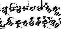 A nomadic people roaming the area west of Gansu during the Han 漢 period, also called “Great Yuezhi” (Dayuezhi 大月支). Some western scholars tried to identify the Yuezhi with Asian people described in Greek (Hellenic) or Roman sources, some say Indo-Iranian people like the Scythians or Parthians could be the same people. A nomadic people roaming the area west of Gansu during the Han 漢 period, also called “Great Yuezhi” (Dayuezhi 大月支). Some western scholars tried to identify the Yuezhi with Asian people described in Greek (Hellenic) or Roman sources, some say Indo-Iranian people like the Scythians or Parthians could be the same people.
Once being a mighty power of the Mongolian steppe, the Yuezhi controlled all neighboring peoples. Even a prince of the mighty Xiongnu 匈奴 federation, Modu, was taken as a hostage at the court of the Yuezhi chieftain. After they had been defeated by the Xiongnu and and the Wusun 烏孫 the Yuezhi wandered to the west. On their way they crossed the Dsungharian Basin (Chinese: Zhunga'r Pendi 准噶爾盆地), the Yili River 伊犁河 and arrived in the Soghdiana and Bactrian area (north of modern Iran) where they were called Sakas (Chinese: Sai 塞) and entered the Indo-Persian history. The original area of the Yuezhi was occupied by the Wusun. In the first century BC the Yuezhi divided into five tribes called yabghu (Chinese: xihou 翕侯), the mightest of these, the Guishuang 貴霜, incorporated the others, and founded the empire of Kushāna, also known as Tukhāristān or Tukhāra (Tokhara, Tochara, Chinese: Tuhuoluo 吐火羅). The Yuezhi spoke an Indo-European language that is known as Tocharian with two different dialects, Tocharian A and B. Their script (see example to the right) is derived the Gupta type of the Brahmi script that was used by the northern Indian rulers in the 5th and 4th century BC. The oldest documents in Tocharian script date the 7th century. |
